-
Our newest and very exciting addition to the Institute for Earth, Computing, Human
and Observing is the Orbital Systems 2.4XLB, Direct Broadcast (DB) Reception System.
This antenna reception system automatically and accurately tracks X and L-band satellites,
like NASA’s X-band Terra and Aqua MODIS, the European Space Agency’s L-band MetOp
EPS, NOAA’s POES HRPT, and China’s Feng Yun 1D CHRPT, in order to receive earth observation
data for science and weather research.
Some of the types of data we receive, process, and analyze are: Fire Mask, Normalized
Difference Vegetation Index (NDVI) and Enhanced Vegetation Index (EVI), Sea Surface
Temperature (SST), Chlorophyll-a Concentration, Cloud Mask, Aerosols, Cloud Top Properties
and Cloud Phase, Atmospheric Profiles, Land Surface Temperature (LST) and Corrected
Reflectance (CREFL). We incorporate the processed data into our Weather and Wave Forecasting
models, Regional Atmospheric Modeling System (RAMS), and Wave Analysis Model (WAMS),
respectively.
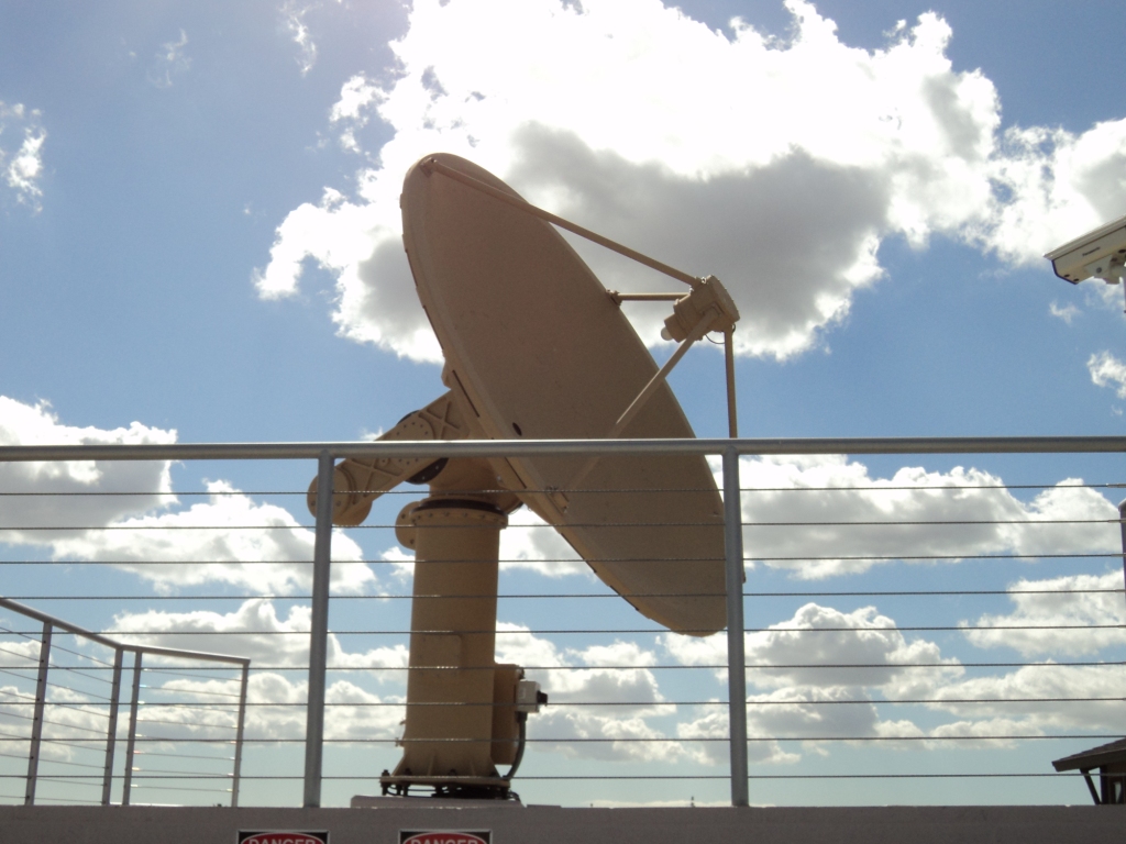
XL Band DB Reception System
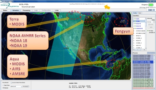
Satellites tracked by the XL Band DB Reception System Antenna
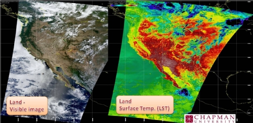
Visible light and land surface temperature image products acquired by XL Band DB Antenna
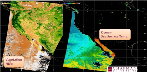
Vegetation greeness index (NDVI) and Sea Surface Temperature image products of Antenna
A MODIS DB ground system consists of the following elements:
- A 3.0- meter EOS Tracker Earth Station with a 15’ space frame ESSCO radome
- A Dell PowerEdge 1900 2.0GHz Quadcore Xeon Linux server
- A 500 GB RAID disk storage and a DLT storage system
- Global Imaging software for data ingest, and
- NASA EOS DB software for data processing through Level 1B.
The receiving system electronics consists of a single integrated LNA/Feed and Downconverter
and one Global SCSI Ingest (GSI) Unit. The GSI unit contains a MODIS receiver card
and a Universal Multi-Satellite (UMS) bit/frame synchronizer. Global Imaging manufactures
the receiver, the bit/frame synchronizer, and the SCSI chassis in which they reside.
A single cable carrying both signal and power connects the receiver to the integrated
feed/downconverter.
The MODIS receiver features QPSK/BPSK/PSK demodulation. The receiver is a versatile
unit that was designed for the next generation of weather satellites. The receiver
offers built-in Viterbi, selectable RF inputs and bandwidths, frequency control, Doppler
tracking, and Q and I baseband output signals.
The Global Imaging UMS bit/frame synchronizer is an advanced universal multi-satellite
synchronizer. The UMS synchronizer accepts bit rates up to 30 mbps and supports CCSDS,
NRZ-L, M, S, and Bi-phase L, M, and S inputs. NESDIS uses our UMS synchronizer equipment
in the Advanced Front EndProcessor (AFEP), which ingests GOES and POES data for processing
and distribution to all US National Weather Services offices.
Satellites from which we are downloading data: Terra, Aqua, NOAA13, NOAA18, NOAA19,
FY1D, METOP
-
RAMS is a highly versatile numerical code for simulation and forecasting meteorological
phenomena, and for depicting the results. Its major components are:
- An atmospheric model that performs the actual simulations
- A data analysis package that prepares initial data for the atmospheric model from
observed meteorological data
- A post-processing visualization and analysis package that interfaces atmospheric model
outputs with a variety of visualization software utilities. It is fundamentally a
limited-area model, but may be configured to cover an area as large as a planetary
hemisphere for simulating mesoscale and large-scale atmospheric systems.
The wave forecasting performed by our group is based on the ECMWF parallel version
of WAM (CYCLE 4) model. It is a third-generation wave model that computes spectra
of random short-crested wind-generated waves and is one of the most popular and well-tested
wave models worldwide (ECMWF, UK Met Office, US Navy, etc.). The resolution used
(0.2 – 0.1 degrees) is the finest used today for the North Pacific Ocean, and this
is the first wave model that solves the complete action density equation, including
non-linear wave-wave interactions.
-
Chapman University has a high-performance computer linux (Centos 5.2) cluster consisting
of 2 master nodes and 12 computing nodes for a total 192 CPUs. The current operational
usage is for an operational high resolution atmospheric model called RAMS (www.atmet.com)
for the area of LA and OC and results are can be seen at: http://forecast.chapman.edu, and a high resolution ocean wave operational model named WAM result are in the webpage:
http://forecast.chapman.edu/wave.php. The cluster is also been used for research projects such as: http://chapmannews.wordpress.com/2011/05/26/schmid-college-wins-major-grant-to-study-climate-change-impact-on-california-agriculture/ and for educational purposes for students that are related to environmental and bioinformatics.
The hardware configuration for each master node is Dual socket Xeon Quad-Core processor,
2.26 GHZ, 8GB L2 RAM, 3-5 SATA drives in RAID configuration (5TB HDD), DVD RAM. The
configuration for each compute node is Dual socket Xeon Quad-Core processor, 4GB RAM,
1 SCSI drive (~250GB HDD), DVD RAM. A file server with 10TB storage capacity, a color
laser printer and a regular desktop (Quad-core, 4GB RAM, 1TB HDD, DVD-RAM), and two
1.5TB external drives to keep backup of the master and compute nodes are also included
in the system. A central net switch and one 24port 10/100Mbps + 1000Mbps smart switch
with 4 Gigabit Ports will connect the compute nodes with the master nodes. A power
back-up UPS system (5×4=20KVA capacity) is also needed to avoid any loss of data.
Arrangements of cooling and AC power lines required for the cluster would be made
through Chapman University’s Utility Services.
Operating Systems: Dual boot with Linux (CentOS 5 64bit and Windows XP 64bit)
Software: Office 2007, Matlab 2009, ArcReader 9.3.1f, ILWIS 3.6.01, Cygwin, HDF Explorer,
GMT, HDFView, R, GrADS, Google Earth, Filezilla, Singular CAS, ArcReader (arcgis),
xming, putty, Filezilla, Google earth, HDF explorer, ILWIS, MatLab(R2011a), MsOffice
2010, Picasa, R 2.9.1 foundation for statistical computing, Singular CAS